
Suhlendorf topographic map
Interactive map
Click on the map to display elevation.
About this map
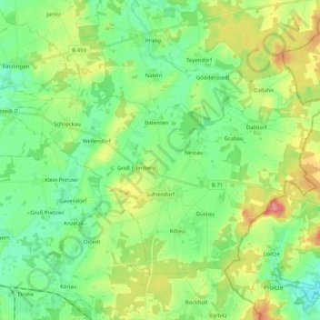
Name: Suhlendorf topographic map, elevation, terrain.
Average elevation: 67 m
Minimum elevation: 41 m
Maximum elevation: 118 m
Other topographic maps
Click on a map to view its topography, its elevation and its terrain.
Kirchweyhe
Duitsland > Nedersaksen > Uelzen > Uelzen
Kirchweyhe, Uelzen, Nedersaksen, 29579, Duitsland
Average elevation: 58 m