
2910 topographic map
Interactive map
Click on the map to display elevation.
About this map
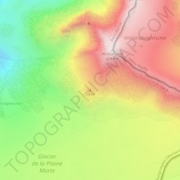
Name: 2910 topographic map, elevation, terrain.
Average elevation: 2,803 m
Minimum elevation: 2,343 m
Maximum elevation: 3,239 m
Other topographic maps
Click on a map to view its topography, its elevation and its terrain.
Lenk
Zwitserland > Bern/Berne > Lenk > Lenk
Lenk, Verwaltungskreis Obersimmental-Saanen, Verwaltungsregion Oberland, Bern/Berne, 3775, Zwitserland
Average elevation: 1,931 m