
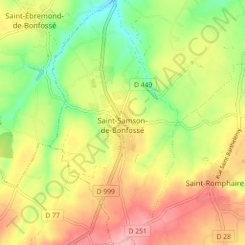
Saint-Samson-de-Bonfossé topographic map
Interactive map
Click on the map to display elevation.
About this map
Name: Saint-Samson-de-Bonfossé topographic map, elevation, terrain.
Average elevation: 95 m
Minimum elevation: 31 m
Maximum elevation: 158 m
Other topographic maps
Click on a map to view its topography, its elevation and its terrain.
La Mabilière
France > Normandie > Manche > Bourgvallées > Saint-Samson-de-Bonfossé
La Mabilière, Saint-Samson-de-Bonfossé, Bourgvallées, Saint-Lô, Manche, Normandie, France métropolitaine, 50750, France
Average elevation: 93 m
Saint-Romphaire
France > Normandie > Manche > Bourgvallées > Saint-Romphaire
Saint-Romphaire, Bourgvallées, Saint-Lô, Manche, Normandie, France métropolitaine, 50750, France
Average elevation: 99 m
Village de la Pasquerie
France > Normandie > Manche > Bourgvallées > Saint-Samson-de-Bonfossé
Village de la Pasquerie, Saint-Samson-de-Bonfossé, Bourgvallées, Saint-Lô, Manche, Normandie, France métropolitaine, 50750, France
Average elevation: 104 m
La Mancellière-sur-Vire
France > Normandie > Manche > Bourgvallées
La Mancellière-sur-Vire, Bourgvallées, Saint-Lô, Manche, Normandie, France métropolitaine, 50750, France
Average elevation: 56 m
Soulles
France > Normandie > Manche > Bourgvallées
Soulles, Bourgvallées, Saint-Lô, Manche, Normandie, France métropolitaine, 50750, France
Average elevation: 121 m