Geolocate

Liberty topographic map

Interactive map

Click on the map to display elevation.

About this map

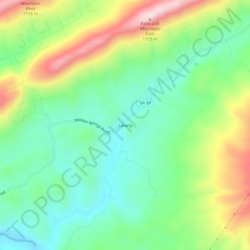
Name: Liberty topographic map, elevation, terrain.

Location: Liberty, Tazewell County, Virginia, United States (37.03678 -81.67400 37.07678 -81.63400)

Average elevation: 832 m

Minimum elevation: 687 m

Maximum elevation: 1,092 m

Other topographic maps

Click on a map to view its topography, its elevation and its terrain.

Pucketts Store

United States > Virginia > Tazewell County

Pucketts Store, Tazewell County, Virginia, 24377, United States

Average elevation: 923 m

Indian

United States > Virginia > Tazewell County > Cedar Bluff

Indian, Cedar Bluff, Tazewell County, Virginia, 24609, United States

Average elevation: 681 m

Burkes Garden

United States > Virginia > Tazewell County

Burkes Garden, Tazewell County, Virginia, 24608, United States

Average elevation: 947 m

Richlands

United States > Virginia > Tazewell County

Richlands, Tazewell County, Virginia, United States

Average elevation: 671 m