
Make a donation
Gear up for your next adventure:
As an Amazon Associate, this site earns from qualifying purchases at no extra cost to you.
Champguyon topographic map
Click on the map to display elevation.
Make a donation
Gear up for your next adventure:
As an Amazon Associate, this site earns from qualifying purchases at no extra cost to you.
Champguyon
Champguyon (French pronunciation: [ʃɑ̃ɡɥijɔ̃]) is a commune in the Marne department, Grand Est region, in north-eastern France. The commune has an area of 16.63 km2 and its altitude ranges from 159 to 214 meters. The nearest larger towns are Esternay (4 km to the south) and Sézanne (14 km to the southeast). As of 2019, there were 146 dwellings in Champguyon, of which 109 main residences.
Make a donation
Gear up for your next adventure:
As an Amazon Associate, this site earns from qualifying purchases at no extra cost to you.
About this map
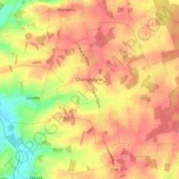
Name: Champguyon topographic map, elevation, terrain.
Average elevation: 181 m
Minimum elevation: 135 m
Maximum elevation: 206 m
Make a donation
Gear up for your next adventure:
As an Amazon Associate, this site earns from qualifying purchases at no extra cost to you.
Other topographic maps
Click on a map to view its topography, its elevation and its terrain.
Make a donation
Gear up for your next adventure:
As an Amazon Associate, this site earns from qualifying purchases at no extra cost to you.