
Île de Phu Quoc topographic map
Interactive map
Click on the map to display elevation.
About this map
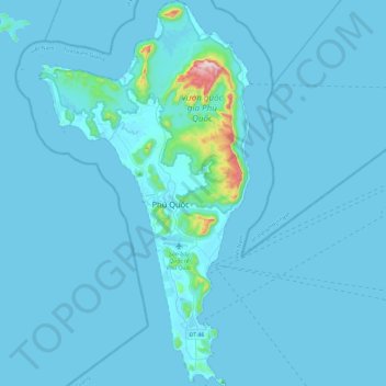
Name: Île de Phu Quoc topographic map, elevation, terrain.
Location: Île de Phu Quoc, Tỉnh Kiên Giang, Viêt Nam (10.00497 103.83250 10.45260 104.08222)
Average elevation: 17 m
Minimum elevation: 0 m
Maximum elevation: 530 m
Other topographic maps
Click on a map to view its topography, its elevation and its terrain.
Sóc Sơn
Viêt Nam > Tỉnh Kiên Giang > Huyện Hòn Đất
Sóc Sơn, Huyện Hòn Đất, Tỉnh Kiên Giang, Viêt Nam
Average elevation: 3 m