
Make a donation
Gear up for your next adventure:
As an Amazon Associate, this site earns from qualifying purchases at no extra cost to you.
Hoh River topographic map
Click on the map to display elevation.
Make a donation
Gear up for your next adventure:
As an Amazon Associate, this site earns from qualifying purchases at no extra cost to you.
Hoh River
The Hoh River Trail, managed by the National Park Service, begins at the national park's Hoh Rain Forest Visitor Center at the end of the Upper Hoh Road. The trail follows the Hoh River east into the heart of the park. After 17.5 mi (28.2 km) it reaches Glacier Meadows near Mount Olympus's Blue Glacier. The Hoh River Trail begins at an altitude of about 600 ft (180 m) and the trail is mostly flat for about 13 mi (21 km), after which it ascends steeply to Glacier Meadows, altitude 4,300 ft (1,300 m). The trail passes through the Hoh Rain Forest, a temperate rain forest, and, closer to Mount Olympus, montane forests and subalpine meadows. There are a number of backcountry campsites along the trail. Mountaineers wishing to climb Mount Olympus typically use the Hoh River Trail to reach the mountain. The climb requires experience with glacier travel and crevasse rescue skills.
Make a donation
Gear up for your next adventure:
As an Amazon Associate, this site earns from qualifying purchases at no extra cost to you.
About this map
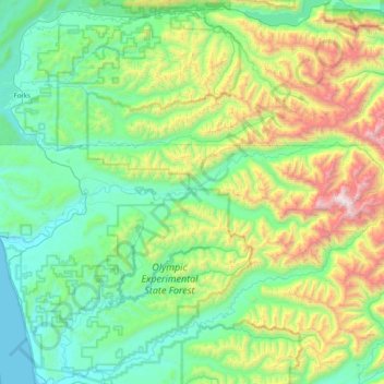
Name: Hoh River topographic map, elevation, terrain.
Location: Hoh River, Jefferson County, Washington, United States (47.74101 -124.43399 47.88389 -123.62099)
Average elevation: 531 m
Minimum elevation: -1 m
Maximum elevation: 2,353 m
Make a donation
Gear up for your next adventure:
As an Amazon Associate, this site earns from qualifying purchases at no extra cost to you.
Other topographic maps
Click on a map to view its topography, its elevation and its terrain.
Make a donation
Gear up for your next adventure:
As an Amazon Associate, this site earns from qualifying purchases at no extra cost to you.
Mount Olympus
United States > Washington > Jefferson County
With notable local relief, Mount Olympus ascends over 2,100 m (6,900 ft) from the 293 m (961 ft) elevation confluence of the Hoh River with Glacier Creek in only 8.8 km (5.5 mi). Mount Olympus has 2,386 m (7,828 ft) of prominence, ranking 5th in the state of Washington.
Average elevation: 1,934 m
Make a donation
Gear up for your next adventure:
As an Amazon Associate, this site earns from qualifying purchases at no extra cost to you.
Port Townsend
United States > Washington > Jefferson County > Port Townsend > Port Townsend
Average elevation: 18 m
Mount Olympus
United States > Washington > Jefferson County
With notable local relief, Mount Olympus ascends over 2,100 m (6,900 ft) from the 293 m (961 ft) elevation confluence of the Hoh River with Glacier Creek in only 8.8 km (5.5 mi). Mount Olympus has 2,386 m (7,828 ft) of prominence, ranking 5th in the state of Washington.
Average elevation: 1,934 m