
Lang Bay topographic map
Interactive map
Click on the map to display elevation.
About this map
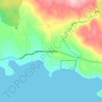
Name: Lang Bay topographic map, elevation, terrain.
Average elevation: 67 m
Minimum elevation: 0 m
Maximum elevation: 232 m
Other topographic maps
Click on a map to view its topography, its elevation and its terrain.
Saltery Bay
Canada > British Columbia > qathet Regional District > Area C (Lois Lake/Saltery Bay)
Saltery Bay, Area C (Lois Lake/Saltery Bay), qathet Regional District, British Columbia, Canada
Average elevation: 83 m
Area C (Lois Lake/Saltery Bay)
Canada > British Columbia > qathet Regional District > Area C (Lois Lake/Saltery Bay)
Area C (Lois Lake/Saltery Bay), qathet Regional District, British Columbia, Canada
Average elevation: 370 m