
Make a donation
Gear up for your next adventure:
As an Amazon Associate, this site earns from qualifying purchases at no extra cost to you.
Queilen topographic map
Click on the map to display elevation.
Make a donation
Gear up for your next adventure:
As an Amazon Associate, this site earns from qualifying purchases at no extra cost to you.
About this map
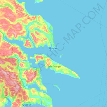
Name: Queilen topographic map, elevation, terrain.
Location: Queilen, Provincia de Chiloé, Los Lagos Region, Chile (-43.10521 -73.74881 -42.71990 -73.15294)
Average elevation: 42 m
Minimum elevation: -1 m
Maximum elevation: 261 m
Make a donation
Gear up for your next adventure:
As an Amazon Associate, this site earns from qualifying purchases at no extra cost to you.
Other topographic maps
Click on a map to view its topography, its elevation and its terrain.
Cabeza de Vaca
Chile > Los Lagos Region > Provincia de Chiloé > Ancud > Cabeza de Vaca
Average elevation: 53 m
Make a donation
Gear up for your next adventure:
As an Amazon Associate, this site earns from qualifying purchases at no extra cost to you.