
Make a donation
Gear up for your next adventure:
As an Amazon Associate, this site earns from qualifying purchases at no extra cost to you.
Steptoe Valley topographic map
Click on the map to display elevation.
Make a donation
Gear up for your next adventure:
As an Amazon Associate, this site earns from qualifying purchases at no extra cost to you.
About this map
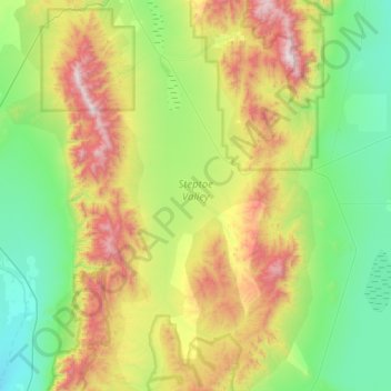
Name: Steptoe Valley topographic map, elevation, terrain.
Location: Steptoe Valley, White Pine County, Nevada, United States (38.75810 -114.89533 39.23234 -114.66860)
Average elevation: 2,142 m
Minimum elevation: 1,650 m
Maximum elevation: 3,291 m
Make a donation
Gear up for your next adventure:
As an Amazon Associate, this site earns from qualifying purchases at no extra cost to you.
Other topographic maps
Click on a map to view its topography, its elevation and its terrain.
Great Basin National Park
United States > Nevada > White Pine County
The park derives its name from the Great Basin, the dry and mountainous region between the Sierra Nevada and the Wasatch Mountains. Topographically, this area is known as the Basin and Range Province. The park is located about 290 miles (470 km) north of Las Vegas and protects 77,180 acres (31,230 ha).
Average elevation: 2,352 m
Ely
United States > Nevada > White Pine County
Ely experiences a semi-arid climate (Köppen BSk), and extreme day-night temperature differences year-round. Ely's nighttime temperatures account for it being listed as one of the coldest places in the contiguous United States, with an average of 214.9 nights per year with a minimum temperature of 32 °F (0…
Average elevation: 2,045 m
Snake Range
United States > Nevada > White Pine County
The Snake Range is a mountain range in White Pine County, Nevada, United States. The south-central portion of the range is included within Great Basin National Park, with most of the remainder included within the Humboldt-Toiyabe National Forest. The range reaches a maximum elevation of 13,065 feet (3,982 m)…
Average elevation: 1,996 m
Make a donation
Gear up for your next adventure:
As an Amazon Associate, this site earns from qualifying purchases at no extra cost to you.
Great Basin National Park
United States > Nevada > White Pine County
The park derives its name from the Great Basin, the dry and mountainous region between the Sierra Nevada and the Wasatch Mountains. Topographically, this area is known as the Basin and Range Province. The park is located about 290 miles (470 km) north of Las Vegas and protects 77,180 acres (31,230 ha).
Average elevation: 2,352 m
Ely
United States > Nevada > White Pine County
Ely experiences a semi-arid climate (Köppen BSk), and extreme day-night temperature differences year-round. Ely's nighttime temperatures account for it being listed as one of the coldest places in the contiguous United States, with an average of 214.9 nights per year with a minimum temperature of 32 °F (0…
Average elevation: 2,045 m
Make a donation
Gear up for your next adventure:
As an Amazon Associate, this site earns from qualifying purchases at no extra cost to you.