
Saint-Romain topographic map
Interactive map
Click on the map to display elevation.
About this map
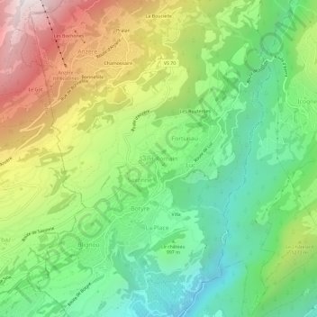
Name: Saint-Romain topographic map, elevation, terrain.
Location: Saint-Romain, Ayent, Hérens, Valais, 1966, Suisse (46.26354 7.39195 46.30354 7.43195)
Average elevation: 1,103 m
Minimum elevation: 535 m
Maximum elevation: 1,999 m
Other topographic maps
Click on a map to view its topography, its elevation and its terrain.
Les Rousses
Suisse > Valais > Hérens > Ayent
Les Rousses, Ayent, Hérens, Valais, 1966, Suisse
Average elevation: 1,779 m