
Casco antiguo topographic map
Interactive map
Click on the map to display elevation.
About this map
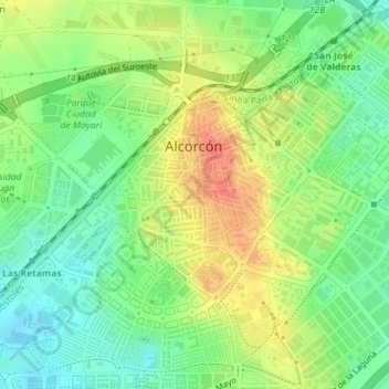
Name: Casco antiguo topographic map, elevation, terrain.
Location: Casco antiguo, Alcorcón, Comunidad de Madrid, España (40.33861 -3.84466 40.35327 -3.81776)
Average elevation: 697 m
Minimum elevation: 672 m
Maximum elevation: 727 m
Other topographic maps
Click on a map to view its topography, its elevation and its terrain.
Suroeste
España > Comunidad de Madrid > Alcorcón
Suroeste, Alcorcón, Comunidad de Madrid, 28922, España
Average elevation: 688 m
Alcorcón
España > Comunidad de Madrid > Alcorcón
Alcorcón, Área metropolitana de Madrid y Corredor del Henares, Comunidad de Madrid, 28921, España
Average elevation: 646 m