
Make a donation
Gear up for your next adventure:
As an Amazon Associate, this site earns from qualifying purchases at no extra cost to you.
Mount Arayat topographic map
Click on the map to display elevation.
Make a donation
Gear up for your next adventure:
As an Amazon Associate, this site earns from qualifying purchases at no extra cost to you.
Mount Arayat
Mount Arayat stands in the middle of the flat Central Luzon Plain, consisting of rice paddies and a typical elevation of about 15 to 35 metres MSL. The mountain is topped by a circular volcanic crater about 1.2 kilometres (0.75 mi) in diameter, much of which has collapsed on the western and part of the northern rim due to erosion. This has resulted in a breached crater which opens in a west-northwest direction. This area is the apparent source of a major debris-avalanche deposit that forms hummocky terrain beyond the west and northwest sides of the volcano. The 1,026-metre (3,366 ft) summit stands on the northeast side of the breached crater, known as North Peak, while the 984-metre (3,228 ft) Pinnacle Peak is located on the southeast crater rim. Post-collapse activity formed an andesitic lava dome known as White Rock in the collapse amphitheater.
Make a donation
Gear up for your next adventure:
As an Amazon Associate, this site earns from qualifying purchases at no extra cost to you.
About this map
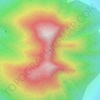
Name: Mount Arayat topographic map, elevation, terrain.
Location: Mount Arayat, Arayat, Pampanga, Central Luzon, Philippines (15.20124 120.74306 15.20134 120.74316)
Average elevation: 639 m
Minimum elevation: 246 m
Maximum elevation: 995 m
Make a donation
Gear up for your next adventure:
As an Amazon Associate, this site earns from qualifying purchases at no extra cost to you.
Other topographic maps
Click on a map to view its topography, its elevation and its terrain.