
Make a donation
Gear up for your next adventure:
As an Amazon Associate, this site earns from qualifying purchases at no extra cost to you.
Vadakara topographic map
Click on the map to display elevation.
Make a donation
Gear up for your next adventure:
As an Amazon Associate, this site earns from qualifying purchases at no extra cost to you.
Vadakara
Vatakara is located at 11°36′N 75°35′E / 11.60°N 75.58°E / 11.60; 75.58 and has an average elevation of 15 m (49 ft). It is situated about 49 km to the north of Kozhikode City, approximately 44 km to the south of Kannur City, and adjacent to Mahé. The town lies by the side of a river variously called the Moorad river, the Kuttiady river, or Kottakkal river. The town's position relative to this river led to it being called Vadakkekara (north bank), later contracted to Vatakara. Towards the east, near the panchayats of Nadapuram and Kuttiady, Vadakara borders the Wayanad district along the Western Ghats section. In the west, like many of the towns in Kerala, Vatakara is flanked by the Arabian Sea. The Kuttiyadi river meets the sea to the south of Vatakara, forming small islands and sandbars near the river mouth.
Make a donation
Gear up for your next adventure:
As an Amazon Associate, this site earns from qualifying purchases at no extra cost to you.
About this map
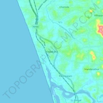
Name: Vadakara topographic map, elevation, terrain.
Location: Vadakara, Kozhikode District, Kerala, 670109, India (11.55707 75.55037 11.63707 75.63037)
Average elevation: 12 m
Minimum elevation: -3 m
Maximum elevation: 121 m
Make a donation
Gear up for your next adventure:
As an Amazon Associate, this site earns from qualifying purchases at no extra cost to you.