Geolocate

Herford topographic map

Interactive map

Click on the map to display elevation.

About this map

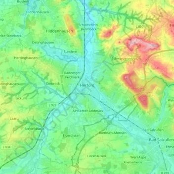
Name: Herford topographic map, elevation, terrain.

Location: Herford, Kreis Herford, North Rhine-Westphalia, Germany (52.05786 8.55705 52.16994 8.75460)

Average elevation: 107 m

Minimum elevation: 56 m

Maximum elevation: 237 m

Other topographic maps

Click on a map to view its topography, its elevation and its terrain.

Kirchlengern

Germany > North Rhine-Westphalia > Kreis Herford

Kirchlengern, Kreis Herford, North Rhine-Westphalia, Germany

Average elevation: 80 m

Spenge

Germany > North Rhine-Westphalia > Kreis Herford

Spenge, Kreis Herford, North Rhine-Westphalia, 32139, Germany

Average elevation: 105 m

Ennigloh

Germany > North Rhine-Westphalia > Kreis Herford > Bünde > Gewinghausen

Ennigloh, Gewinghausen, Bünde, Kreis Herford, North Rhine-Westphalia, 32257, Germany

Average elevation: 77 m

Herford

Germany > North Rhine-Westphalia > Kreis Herford

Herford, Kreis Herford, North Rhine-Westphalia, Germany

Average elevation: 91 m