
Make a donation
Gear up for your next adventure:
As an Amazon Associate, this site earns from qualifying purchases at no extra cost to you.
Sachsendorf topographic map
Click on the map to display elevation.
Make a donation
Gear up for your next adventure:
As an Amazon Associate, this site earns from qualifying purchases at no extra cost to you.
About this map
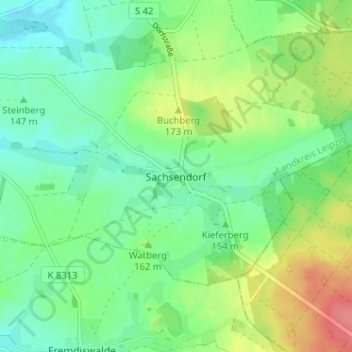
Name: Sachsendorf topographic map, elevation, terrain.
Location: Sachsendorf, Wurzen, Landkreis Leipzig, Sachsen, Deutschland (51.29750 12.83752 51.33750 12.87752)
Average elevation: 157 m
Minimum elevation: 134 m
Maximum elevation: 202 m
Make a donation
Gear up for your next adventure:
As an Amazon Associate, this site earns from qualifying purchases at no extra cost to you.
Other topographic maps
Click on a map to view its topography, its elevation and its terrain.
Wurzen
Deutschland > Sachsen > Landkreis Leipzig > Wurzen
Die Entwicklung der Stadt erreichte im 15. und 16. Jahrhundert einen Höhepunkt, als die Bischöfe von Meißen zeitweise hier residierten und eine nennenswerte Bautätigkeit entfalteten (Schloss, Domerweiterung, Stadtkirche St. Wenceslai). Nach der Teilung der wettinischen Lande (1485) wurde die…
Average elevation: 128 m