Geolocate

Porth topographic map

Click on the map to display elevation.

About this map

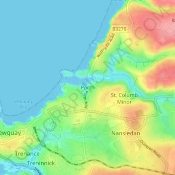
Name: Porth topographic map, elevation, terrain.

Location: Porth, Newquay, Cornwall, England, TR7 3FG, United Kingdom (50.40370 -5.07608 50.44370 -5.03608)

Average elevation: 28 m

Minimum elevation: -1 m

Maximum elevation: 92 m

Cornwall trails, hiking, mountain biking, running and outdoor activities

Other topographic maps

Click on a map to view its topography, its elevation and its terrain.

Watergate Bay

United Kingdom > England > Cornwall > Newquay > Tregurrian

Average elevation: 12 m

Gear up for your next adventure:

GPS Outdoor Watches - Watches with GPS tracking for hiking and exploration
📚UK Hiking Guidebooks - Detailed route descriptions for the Lake District, Peaks, and Highlands
🧴Tick Removal Tools - Small, essential health tool for UK woodland and moorland
🧰Survival Kits - Emergency tools for remote environments
🩹Hiking First Aid Kits - Compact medical kits tailored for trail injuries and emergencies

As an Amazon Associate, this site earns from qualifying purchases at no extra cost to you.