
Make a donation
Gear up for your next adventure:
As an Amazon Associate, this site earns from qualifying purchases at no extra cost to you.
Westwood topographic map
Click on the map to display elevation.
Make a donation
Gear up for your next adventure:
As an Amazon Associate, this site earns from qualifying purchases at no extra cost to you.
About this map
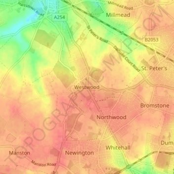
Name: Westwood topographic map, elevation, terrain.
Average elevation: 40 m
Minimum elevation: 4 m
Maximum elevation: 56 m
Kent trails, hiking, mountain biking, running and outdoor activities
Make a donation
Gear up for your next adventure:
As an Amazon Associate, this site earns from qualifying purchases at no extra cost to you.
Other topographic maps
Click on a map to view its topography, its elevation and its terrain.
Stour
United Kingdom > England > Kent > Thanet District
The source, of what is known at that point as the Great Stour, is near the village of Lenham, within a short distance of the River Len, a tributary of the Medway. The source is at a high elevation close to the North Downs escarpment. At first the river flows south east in a narrow valley parallel to the…
Average elevation: 7 m