
Altötting topographic map
Interactive map
Click on the map to display elevation.
About this map
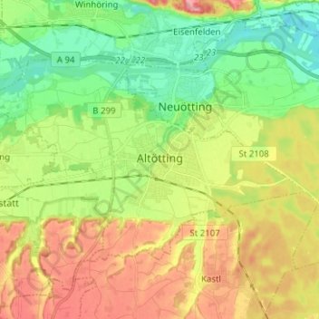
Name: Altötting topographic map, elevation, terrain.
Location: Altötting, Landkreis Altötting, Bavaria, 84503, Germany (48.19974 12.60763 48.25306 12.73285)
Average elevation: 406 m
Minimum elevation: 354 m
Maximum elevation: 477 m
Other topographic maps
Click on a map to view its topography, its elevation and its terrain.
Burghausen
Germany > Bavaria > Landkreis Altötting
Burghausen, Landkreis Altötting, Bavaria, 84489, Germany
Average elevation: 423 m