
Thank you for supporting this site ❤️
Make a donation
Make a donation
Gear up for your next adventure:
As an Amazon Associate, this site earns from qualifying purchases at no extra cost to you.
Logiano topographic map
Click on the map to display elevation.
Thank you for supporting this site ❤️
Make a donation
Make a donation
Gear up for your next adventure:
As an Amazon Associate, this site earns from qualifying purchases at no extra cost to you.
About this map
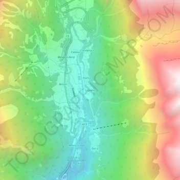
Name: Logiano topographic map, elevation, terrain.
Location: Logiano, Mesocco, Moësa, Grisons, 6563, Switzerland (46.37495 9.21709 46.41495 9.25709)
Average elevation: 1,336 m
Minimum elevation: 592 m
Maximum elevation: 2,489 m
Thank you for supporting this site ❤️
Make a donation
Make a donation
Gear up for your next adventure:
As an Amazon Associate, this site earns from qualifying purchases at no extra cost to you.