
Kuldīgas novads topographic map
Interactive map
Click on the map to display elevation.
About this map
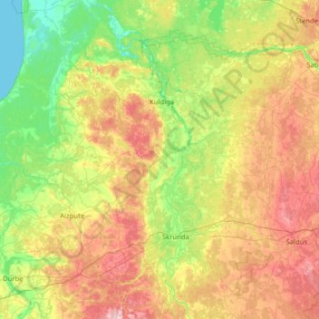
Name: Kuldīgas novads topographic map, elevation, terrain.
Location: Kuldīgas novads, Kurzeme, Lettonie (56.49760 21.39423 57.18598 22.50434)
Average elevation: 59 m
Minimum elevation: -1 m
Maximum elevation: 176 m
Other topographic maps
Click on a map to view its topography, its elevation and its terrain.
Kuldīga
Lettonie > Kurzeme > Kuldīgas novads
Kuldīga, Kuldīgas novads, Kurzeme, LV-3301, Lettonie
Average elevation: 38 m
Gudenieki
Lettonie > Kurzeme > Kuldīgas novads
Gudenieki, Kuldīgas novads, Kurzeme, LV-3312, Lettonie
Average elevation: 40 m