
Brocton topographic map
Click on the map to display elevation.
About this map
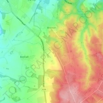
Name: Brocton topographic map, elevation, terrain.
Location: Brocton, Stafford, Staffordshire, England, United Kingdom (52.73630 -2.07617 52.78589 -2.01479)
Average elevation: 142 m
Minimum elevation: 75 m
Maximum elevation: 226 m
Staffordshire trails, hiking, mountain biking, running and outdoor activities
Other topographic maps
Click on a map to view its topography, its elevation and its terrain.
Knightley
United Kingdom > England > Staffordshire > Stafford > Gnosall > Knightley
Average elevation: 127 m
Drointon
United Kingdom > England > Staffordshire > Stafford > Stowe-by-Chartley
Average elevation: 110 m