
Thank you for supporting this site ❤️
Make a donation
Make a donation
Gear up for your next adventure:
As an Amazon Associate, this site earns from qualifying purchases at no extra cost to you.
Hull topographic map
Click on the map to display elevation.
Thank you for supporting this site ❤️
Make a donation
Make a donation
Gear up for your next adventure:
As an Amazon Associate, this site earns from qualifying purchases at no extra cost to you.
Hull
Hull is located at 27°07′08″N 81°56′31″W / 27.119°N 81.942°W / 27.119; -81.942, with an elevation of 39 feet (12 m).
Thank you for supporting this site ❤️
Make a donation
Make a donation
Gear up for your next adventure:
As an Amazon Associate, this site earns from qualifying purchases at no extra cost to you.
About this map
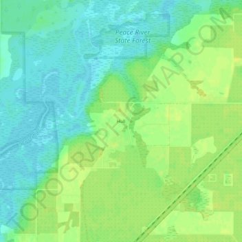
Name: Hull topographic map, elevation, terrain.
Location: Hull, DeSoto County, Florida, 34267, United States (27.09922 -81.96231 27.13922 -81.92231)
Average elevation: 10 m
Minimum elevation: 1 m
Maximum elevation: 17 m
Thank you for supporting this site ❤️
Make a donation
Make a donation
Gear up for your next adventure:
As an Amazon Associate, this site earns from qualifying purchases at no extra cost to you.