
Thank you for supporting this site ❤️
Make a donation
Make a donation
Gear up for your next adventure:
As an Amazon Associate, this site earns from qualifying purchases at no extra cost to you.
Uripa topographic map
Click on the map to display elevation.
Thank you for supporting this site ❤️
Make a donation
Make a donation
Gear up for your next adventure:
As an Amazon Associate, this site earns from qualifying purchases at no extra cost to you.
About this map
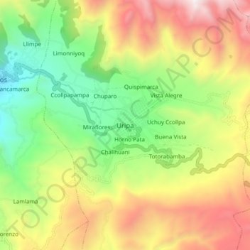
Name: Uripa topographic map, elevation, terrain.
Location: Uripa, Anco-Huallo, Province of Chincheros, Apurímac, Peru (-13.57278 -73.71790 -13.49278 -73.63790)
Average elevation: 3,582 m
Minimum elevation: 2,810 m
Maximum elevation: 4,577 m
Thank you for supporting this site ❤️
Make a donation
Make a donation
Gear up for your next adventure:
As an Amazon Associate, this site earns from qualifying purchases at no extra cost to you.