
Limayrac topographic map
Interactive map
Click on the map to display elevation.
About this map
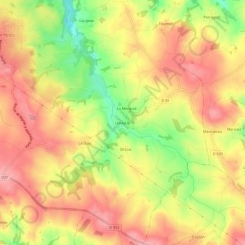
Name: Limayrac topographic map, elevation, terrain.
Average elevation: 668 m
Minimum elevation: 591 m
Maximum elevation: 718 m
Other topographic maps
Click on a map to view its topography, its elevation and its terrain.
Les Parras
France > Occitanie > Aveyron > Colombiès > Les Parras
Les Parras, Colombiès, Villefranche-de-Rouergue, Aveyron, Occitanie, France métropolitaine, 12240, France
Average elevation: 531 m