
Goshen topographic map
Interactive map
Click on the map to display elevation.
About this map
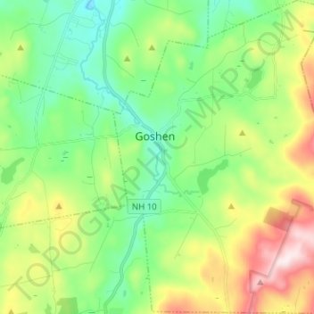
Name: Goshen topographic map, elevation, terrain.
Location: Goshen, Sullivan County, New Hampshire, 03752, United States (43.24895 -72.16550 43.34080 -72.06328)
Average elevation: 419 m
Minimum elevation: 249 m
Maximum elevation: 765 m
The long ridge of Mount Sunapee occupies the eastern edge of town. The highest point in Goshen is an unnamed knob on the ridge (near Goves Mountain) where the elevation reaches 2,529 feet (771 m) above sea level.