
Thank you for supporting this site ❤️
Make a donation
Make a donation
Gear up for your next adventure:
As an Amazon Associate, this site earns from qualifying purchases at no extra cost to you.
Sacapalca topographic map
Click on the map to display elevation.
Thank you for supporting this site ❤️
Make a donation
Make a donation
Gear up for your next adventure:
As an Amazon Associate, this site earns from qualifying purchases at no extra cost to you.
About this map
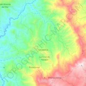
Name: Sacapalca topographic map, elevation, terrain.
Location: Sacapalca, Gonzanama, Loja, Ecuador (-4.20906 -79.59997 -4.07831 -79.45907)
Average elevation: 1,526 m
Minimum elevation: 926 m
Maximum elevation: 2,651 m
Thank you for supporting this site ❤️
Make a donation
Make a donation
Gear up for your next adventure:
As an Amazon Associate, this site earns from qualifying purchases at no extra cost to you.