Geolocate

Llandrillo topographic map

Click on the map to display elevation.

About this map

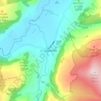
Name: Llandrillo topographic map, elevation, terrain.

Location: Llandrillo, Denbighshire, Wales, LL21 0SQ, United Kingdom (52.90217 -3.45449 52.94217 -3.41449)

Average elevation: 272 m

Minimum elevation: 141 m

Maximum elevation: 550 m

Denbighshire trails, hiking, mountain biking, running and outdoor activities

Other topographic maps

Click on a map to view its topography, its elevation and its terrain.

River Clwyd

United Kingdom > Wales > Denbighshire

Average elevation: 214 m

Clawddnewydd

United Kingdom > Wales > Denbighshire

Average elevation: 246 m

Betws Gwerfil Goch

United Kingdom > Wales > Denbighshire

Average elevation: 297 m

River Dee

United Kingdom > Wales > Denbighshire > Corwen > Bonwm

Average elevation: 244 m

Clwydian Range and Dee Valley National Landscape

United Kingdom > Wales > Denbighshire

Separated by the Vale of Alyn, a second sister range, sometimes regarded (at least partly) as part of the Clwydian Range and included in the AONB since 2011, the Llantysilio and Maesyrchen Mountains, or South Clwyd Mountains extend further south to Acrefair and Gwyddelwern. Alongside the (core–northern)…

Average elevation: 166 m

Brenig Reservoir

United Kingdom > Wales > Denbighshire

Average elevation: 410 m

Gwyddelwern

United Kingdom > Wales > Denbighshire

Average elevation: 249 m

Nantglyn

United Kingdom > Wales > Denbighshire

Average elevation: 352 m

Betws Gwerfil Goch

United Kingdom > Wales > Denbighshire

Average elevation: 297 m

Llangynhafal

United Kingdom > Wales > Denbighshire > Gellifor

Average elevation: 160 m

Parc Pendre

United Kingdom > Wales > Denbighshire > Prestatyn

Average elevation: 53 m

Llanelidan

United Kingdom > Wales > Denbighshire > Llanelidan

Average elevation: 221 m

Gronant Dunes

United Kingdom > Wales > Denbighshire > Prestatyn

Average elevation: 11 m

Tremeirchion

United Kingdom > Wales > Denbighshire

Average elevation: 123 m

Gear up for your next adventure:

🪓Outdoor Multitools - Versatile tools for hiking and camping
🖼️Topographic Map Art - Decorative 3D-effect posters of famous UK peaks and regions
🥤Hydration Bladders - Hands-free hydration systems for backpacks
🔥Emergency Fire Starters - Reliable ignition tools for survival situations in damp conditions
🗺️Ordnance Survey Maps - Official UK maps for walking and outdoor activities

As an Amazon Associate, this site earns from qualifying purchases at no extra cost to you.