
Thank you for supporting this site ❤️
Make a donation
Make a donation
Gear up for your next adventure:
As an Amazon Associate, this site earns from qualifying purchases at no extra cost to you.
Schafberg topographic map
Click on the map to display elevation.
Thank you for supporting this site ❤️
Make a donation
Make a donation
Gear up for your next adventure:
As an Amazon Associate, this site earns from qualifying purchases at no extra cost to you.
About this map
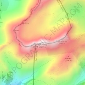
Name: Schafberg topographic map, elevation, terrain.
Location: Schafberg, Plaffeien, Sensebezirk, Fribourg, 1716, Switzerland (46.63697 7.31637 46.63707 7.31647)
Average elevation: 1,815 m
Minimum elevation: 1,316 m
Maximum elevation: 2,220 m
Thank you for supporting this site ❤️
Make a donation
Make a donation
Gear up for your next adventure:
As an Amazon Associate, this site earns from qualifying purchases at no extra cost to you.