
Utrechtse Heuvelrug topographic map
Interactive map
Click on the map to display elevation.
Utrechtse Heuvelrug
Dutch topographic map of the municipality of Utrechtse Heuvelrug, June 2015
About this map
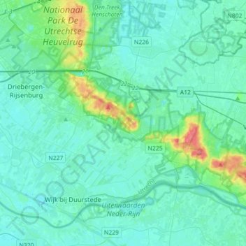
Name: Utrechtse Heuvelrug topographic map, elevation, terrain.
Location: Utrechtse Heuvelrug, Utrecht, Netherlands (51.97073 5.24699 52.08657 5.52938)
Average elevation: 10 m
Minimum elevation: -3 m
Maximum elevation: 72 m
Other topographic maps
Click on a map to view its topography, its elevation and its terrain.