
Sindringen topographic map
Interactive map
Click on the map to display elevation.
About this map
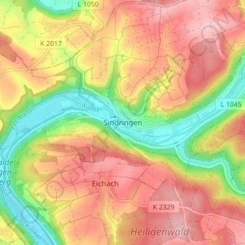
Name: Sindringen topographic map, elevation, terrain.
Average elevation: 275 m
Minimum elevation: 177 m
Maximum elevation: 353 m
Other topographic maps
Click on a map to view its topography, its elevation and its terrain.
Ernsbach
Deutschland > Baden-Württemberg > Hohenlohekreis > Forchtenberg
Ernsbach, Forchtenberg, Verwaltungsverband Mittleres Kochertal, Hohenlohekreis, Baden-Württemberg, 74670, Deutschland
Average elevation: 297 m
Muthof
Deutschland > Baden-Württemberg > Hohenlohekreis > Forchtenberg
Muthof, Forchtenberg, Verwaltungsverband Mittleres Kochertal, Hohenlohekreis, Baden-Württemberg, 74670, Deutschland
Average elevation: 296 m