Geolocate

Sector 8 topographic map

Click on the map to display elevation.

About this map

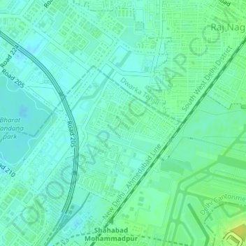
Name: Sector 8 topographic map, elevation, terrain.

Location: Sector 8, Bagdola, Delhi Cantonment, New Delhi, Delhi, India (28.56196 77.06545 28.58018 77.08020)

Average elevation: 216 m

Minimum elevation: 210 m

Maximum elevation: 229 m

Other topographic maps

Click on a map to view its topography, its elevation and its terrain.

Mahipalpur

India > Delhi > New Delhi

Average elevation: 247 m

Ghitorni

India > Delhi > New Delhi

Average elevation: 268 m

D1 Janakpuri Park

India > Delhi > New Delhi

Average elevation: 219 m

Gear up for your next adventure:

🥤Hiking Water Bottles - Reusable bottles for hydration on the trail
GPS Outdoor Watches - Watches with GPS tracking for hiking and exploration
🕶️Polarized Sunglasses - Reduces glare from snow and water when reading terrain
🧣Neck Gaiters - Versatile protection against wind and cold
🔦Head Torches - Hands-free lighting for hiking and camping

As an Amazon Associate, this site earns from qualifying purchases at no extra cost to you.