
Lázaro Cárdenas topographic map
Interactive map
Click on the map to display elevation.
About this map
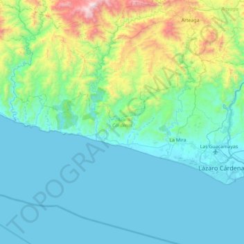
Name: Lázaro Cárdenas topographic map, elevation, terrain.
Location: Lázaro Cárdenas, Michoacán, Mexique (17.91491 -102.80185 18.25041 -102.11074)
Average elevation: 313 m
Minimum elevation: -2 m
Maximum elevation: 2,090 m
Other topographic maps
Click on a map to view its topography, its elevation and its terrain.
Buenos Aires
Mexique > Michoacán > Lázaro Cárdenas
Buenos Aires, Lázaro Cárdenas, Michoacán, 60983, Mexique
Average elevation: 56 m
Ciudad Hidalgo
Ciudad Hidalgo, Hidalgo, Michoacán, Mexique
Average elevation: 2,169 m