
Sonneborn topographic map
Interactive map
Click on the map to display elevation.
About this map
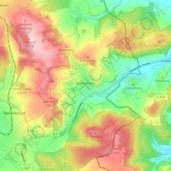
Name: Sonneborn topographic map, elevation, terrain.
Average elevation: 233 m
Minimum elevation: 133 m
Maximum elevation: 343 m
Other topographic maps
Click on a map to view its topography, its elevation and its terrain.
Alverdissen
Deutschland > Nordrhein-Westfalen > Kreis Lippe > Barntrup
Alverdissen, Barntrup, Kreis Lippe, Nordrhein-Westfalen, Deutschland
Average elevation: 256 m