
Kolmbach topographic map
Interactive map
Click on the map to display elevation.
About this map
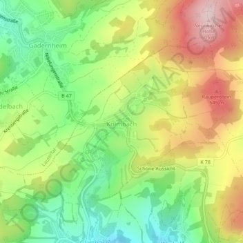
Name: Kolmbach topographic map, elevation, terrain.
Location: Kolmbach, Lindenfels, Kreis Bergstraße, Hessen, Deutschland (49.69851 8.73823 49.71677 8.77275)
Average elevation: 433 m
Minimum elevation: 292 m
Maximum elevation: 607 m
Die Historisch-topographisch-statistische Beschreibung des Fürstenthums Lorsch, oder Kirchengeschichte des Oberrheingaues beschreibt 1812 über Kolmbach als Ort der „Zent Fürth“:
Other topographic maps
Click on a map to view its topography, its elevation and its terrain.
Lindenfels
Deutschland > Hessen > Kreis Bergstraße > Lindenfels > Lindenfels
Lindenfels, Kreis Bergstraße, Hessen, 64678, Deutschland
Average elevation: 321 m