
Mount Everts topographic map
Interactive map
Click on the map to display elevation.
About this map
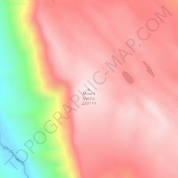
Name: Mount Everts topographic map, elevation, terrain.
Location: Mount Everts, Park County, Wyoming, VS (44.97489 -110.66137 44.97499 -110.66127)
Average elevation: 2,192 m
Minimum elevation: 1,759 m
Maximum elevation: 2,388 m
Other topographic maps
Click on a map to view its topography, its elevation and its terrain.
Yellowstone National Park
Yellowstone National Park, Mary Mountain-Nez Perce, Teton County, Wyoming, VS
Average elevation: 2,450 m
Grand Teton National Park
Grand Teton National Park, Teton Park Road, Teton County, Wyoming, 83013, VS
Average elevation: 2,409 m