
La Grange topographic map
Interactive map
Click on the map to display elevation.
About this map
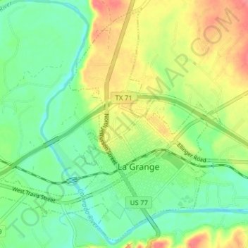
Name: La Grange topographic map, elevation, terrain.
Location: La Grange, Fayette County, Texas, United States (29.89160 -96.91546 29.94326 -96.85196)
Average elevation: 91 m
Minimum elevation: 64 m
Maximum elevation: 141 m
The center of La Grange has an elevation of 266 feet (81 m) above sea level.
Other topographic maps
Click on a map to view its topography, its elevation and its terrain.
Carmine
United States > Texas > Fayette County > Carmine
Carmine, Fayette County, Texas, United States
Average elevation: 136 m
Round Top
United States > Texas > Fayette County
Round Top, Fayette County, Texas, United States
Average elevation: 119 m