
Make a donation
Gear up for your next adventure:
As an Amazon Associate, this site earns from qualifying purchases at no extra cost to you.
Montorgueil topographic map
Click on the map to display elevation.
Make a donation
Gear up for your next adventure:
As an Amazon Associate, this site earns from qualifying purchases at no extra cost to you.
About this map
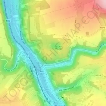
Name: Montorgueil topographic map, elevation, terrain.
Location: Montorgueil, Leffe, Dinant, Namur, Wallonie, 5500, Belgique (50.26270 4.90028 50.28270 4.92028)
Average elevation: 175 m
Minimum elevation: 85 m
Maximum elevation: 282 m
Make a donation
Gear up for your next adventure:
As an Amazon Associate, this site earns from qualifying purchases at no extra cost to you.
Other topographic maps
Click on a map to view its topography, its elevation and its terrain.
Lisogne
Belgique > Namur > Dinant > Dinant
À 6,5 km de Dinant, le village de Lisogne se situe sur un plateau dominant le versant nord du ruisseau des Fonds de Leffe et la rive droite de la vallée de la Meuse. Le relief de Lisogne est assez accidenté et fortement entaillé par le ruisseau des Fonds de Leffe. L'altitude varie entre 180 m et 295 m sur…
Average elevation: 246 m
Falmagne
Belgique > Namur > Dinant > Dinant
Falmagne est situé au sud de la vallée de la Lesse (un affluent de la Meuse), à la limite entre les zones géologiques du Condroz et de la Famenne. À une altitude d'environ 230 m, il est situé sur un plateau et surplombe le village de Falmignoul.
Average elevation: 228 m
Make a donation
Gear up for your next adventure:
As an Amazon Associate, this site earns from qualifying purchases at no extra cost to you.
Furfooz
Belgique > Namur > Dinant > Dinant
Furfooz est aussi connu pour ses vestiges de la Préhistoire (découverts dans certaines de ses grottes) ainsi que de l'époque romaine. À ce jour, le parc de Furfooz permet la visite des restes d'un ancien camp romain dominant de quelque 100 m d'altitude la Lesse, sur un monticule surnommé la Haute-Racine.
Average elevation: 211 m