Geolocate

Hometown topographic map

Click on the map to display elevation.

Hometown

According to the United States Census Bureau, the CDP has a total area of 2.0 square miles (5.2 km2), all land. Hometown is located 2 miles (3.2 km) north of Tamaqua and 10 miles (16 km) south of Hazleton at the intersections of Route 54 and 309. Hometown's elevation is 1,129 feet (344 m) above sea level. It uses the Tamaqua zip code of 18252.

Wikipedia (CC-BY-SA 3.0)

About this map

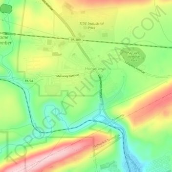
Name: Hometown topographic map, elevation, terrain.

Location: Hometown, Rush Township, Schuylkill County, Pennsylvania, United States (40.80897 -76.00650 40.83084 -75.95851)

Average elevation: 352 m

Minimum elevation: 249 m

Maximum elevation: 481 m

Gear up for your next adventure:

🧺Ultralight Dry Bags - Organize and waterproof your gear inside your rucksack
🎒Multi-day Trekking Packs - Large capacity backpacks for wild camping and long-distance trails
🛑Emergency Bivvy Bags - Heat-reflective survival bags for unexpected nights out
🧊Insulated Flasks - Keeps drinks hot or cold during hikes
🧢Thermal Beanie Hats - Prevent heat loss from the head in windy summit conditions

As an Amazon Associate, this site earns from qualifying purchases at no extra cost to you.