
Pyeongchang-dong topographic map
Interactive map
Click on the map to display elevation.
About this map
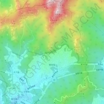
Name: Pyeongchang-dong topographic map, elevation, terrain.
Location: Pyeongchang-dong, Jongno-gu, Seoul, South Korea (37.59870 126.94890 37.63235 126.98680)
Average elevation: 268 m
Minimum elevation: 58 m
Maximum elevation: 698 m
Other topographic maps
Click on a map to view its topography, its elevation and its terrain.