
Make a donation
Gear up for your next adventure:
As an Amazon Associate, this site earns from qualifying purchases at no extra cost to you.
Texas topographic map
Click on the map to display elevation.
Make a donation
Gear up for your next adventure:
As an Amazon Associate, this site earns from qualifying purchases at no extra cost to you.
About this map
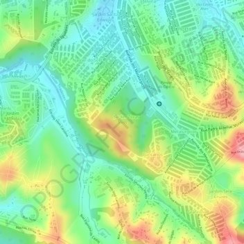
Name: Texas topographic map, elevation, terrain.
Average elevation: 834 m
Minimum elevation: 783 m
Maximum elevation: 912 m
Make a donation
Gear up for your next adventure:
As an Amazon Associate, this site earns from qualifying purchases at no extra cost to you.
Other topographic maps
Click on a map to view its topography, its elevation and its terrain.
São Paulo
Brazil > São Paulo > Região Metropolitana de São Paulo > São Paulo
São Paulo is in Southeastern Brazil, in southeastern São Paulo State, approximately halfway between Curitiba and Rio de Janeiro. The city is on a plateau placed beyond the Serra do Mar (Portuguese for "Sea Range" or "Coastal Range"), itself a component of the vast region known as the Brazilian Highlands,…
Average elevation: 785 m
Parque Estadual da Cantareira
Brazil > São Paulo > Região Metropolitana de São Paulo > São Paulo
There are four visitor centers: Pedra Grande, Engordador, Águas Claras and Cabuçu. The Pedra Grande center has a lookout over the city at 1,010 metres (3,310 ft) of altitude. The park is open for scheduled school groups during the week, and to the general public on weekends. It is an important leisure…
Average elevation: 841 m
Make a donation
Gear up for your next adventure:
As an Amazon Associate, this site earns from qualifying purchases at no extra cost to you.
Bela Vista
Brazil > São Paulo > Região Metropolitana de São Paulo > São Paulo
Average elevation: 796 m
Casa Verde
Brazil > São Paulo > Região Metropolitana de São Paulo > São Paulo
Average elevation: 748 m
Make a donation
Gear up for your next adventure:
As an Amazon Associate, this site earns from qualifying purchases at no extra cost to you.
José Bonifácio
Brazil > São Paulo > Região Metropolitana de São Paulo > São Paulo
Average elevation: 793 m
Itaim Paulista
Brazil > São Paulo > Região Metropolitana de São Paulo > São Paulo
Average elevation: 762 m
Make a donation
Gear up for your next adventure:
As an Amazon Associate, this site earns from qualifying purchases at no extra cost to you.