
Didsari topographic map
Interactive map
Click on the map to display elevation.
About this map
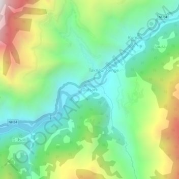
Name: Didsari topographic map, elevation, terrain.
Location: Didsari, Bhatwari, Uttarkashi district, Uttarakhand, India (30.74244 78.56919 30.78244 78.60919)
Average elevation: 1,801 m
Minimum elevation: 1,349 m
Maximum elevation: 2,709 m
Other topographic maps
Click on a map to view its topography, its elevation and its terrain.
Gangotri National Park
India > Uttarakhand > Bhatwari
The park harbors Western Himalayan subalpine conifer forests at lower elevations and Western Himalayan alpine shrub and meadows at higher elevations. Vegetation consist of chirpine deodar, fir, spruce, oak and rhododendrons.
Average elevation: 5,008 m