
Calico Rock topographic map
Interactive map
Click on the map to display elevation.
About this map
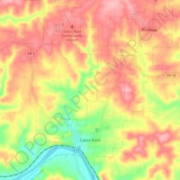
Name: Calico Rock topographic map, elevation, terrain.
Location: Calico Rock, Izard County, Arkansas, United States (36.10381 -92.16811 36.17459 -92.11036)
Average elevation: 179 m
Minimum elevation: 96 m
Maximum elevation: 238 m
Other topographic maps
Click on a map to view its topography, its elevation and its terrain.
Horseshoe Bend
United States > Arkansas > Izard County
Horseshoe Bend, Izard County, Arkansas, 72512, United States
Average elevation: 216 m