
Solwezi topographic map
Interactive map
Click on the map to display elevation.
Solwezi
Solwezi is located on the Chingola–Solwezi–Mwinilunga Road (T5 Road of Zambia), approximately 177 kilometres (110 mi) north-west of Chingola and approximately 275 kilometres (171 mi) south-east of Mwinilunga, in the extreme northwest of the country. The geographical coordinates of the city are:12°08'36.0"S, 26°23'09.0"E (Latitude:-12.143333; Longitude:26.385833). Solwezi sits at an average elevation of 1,397 metres (4,583 ft) above mean sea level.
About this map
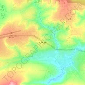
Name: Solwezi topographic map, elevation, terrain.
Location: Solwezi, Solwezi District, North-Western Province, Zambia (-12.22206 26.35907 -12.14206 26.43907)
Average elevation: 1,352 m
Minimum elevation: 1,297 m
Maximum elevation: 1,422 m
Other topographic maps
Click on a map to view its topography, its elevation and its terrain.
Mwinilunga
Zambia > North-Western Province
Mwinilunga sits in the extreme north-western corner of the country, close to the international borders with Angola and the Democratic Republic of the Congo. The geographical coordinates of Mwinilunga, Zambia are:11°43'02.0"S, 24°25'44.0"E (Latitude:-11.717222; Longitude:24.428889). The average elevation of…
Average elevation: 1,345 m