
Make a donation
Gear up for your next adventure:
As an Amazon Associate, this site earns from qualifying purchases at no extra cost to you.
Shawnigan Lake topographic map
Click on the map to display elevation.
Make a donation
Gear up for your next adventure:
As an Amazon Associate, this site earns from qualifying purchases at no extra cost to you.
About this map
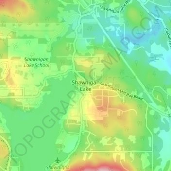
Name: Shawnigan Lake topographic map, elevation, terrain.
Average elevation: 128 m
Minimum elevation: 71 m
Maximum elevation: 242 m
Make a donation
Gear up for your next adventure:
As an Amazon Associate, this site earns from qualifying purchases at no extra cost to you.
Other topographic maps
Click on a map to view its topography, its elevation and its terrain.
Koksilah River
Canada > British Columbia > Cowichan Valley Regional District > Area B (Shawnigan Lake)
Average elevation: 171 m
Koksilah River
Canada > British Columbia > Cowichan Valley Regional District > Area B (Shawnigan Lake)
Average elevation: 174 m
West Shawnigan Lake Provincial Park
Canada > British Columbia > Cowichan Valley Regional District > Area B (Shawnigan Lake)
Average elevation: 154 m