Geolocate

Pickwick topographic map

Click on the map to display elevation.

About this map

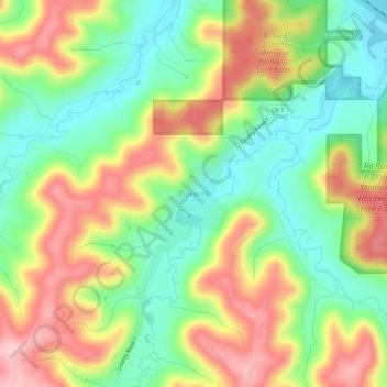
Name: Pickwick topographic map, elevation, terrain.

Location: Pickwick, Winona County, Minnesota, United States (43.96163 -91.51459 44.00163 -91.47459)

Average elevation: 278 m

Minimum elevation: 194 m

Maximum elevation: 384 m

Other topographic maps

Click on a map to view its topography, its elevation and its terrain.

Winona

United States > Minnesota > Winona County

Average elevation: 272 m

Saint Charles

United States > Minnesota > Winona County

Average elevation: 367 m

Rollingstone

United States > Minnesota > Winona County

Average elevation: 262 m

Elba Township

United States > Minnesota > Winona County

Average elevation: 319 m

Winona

United States > Minnesota > Winona County

Average elevation: 272 m

Gear up for your next adventure:

🚲Cycling GPS Computers - Track elevation and topographic routes on two wheels
🧴Sport Sunscreen Sticks - High-protection sunblock that won't run into your eyes on the trail
🗺️Ordnance Survey Maps - Official UK maps for walking and outdoor activities
🧥Softshell Jackets - Breathable jackets for active outdoor use
🎒Multi-day Trekking Packs - Large capacity backpacks for wild camping and long-distance trails

As an Amazon Associate, this site earns from qualifying purchases at no extra cost to you.