Geolocate

Winona topographic map

Click on the map to display elevation.

About this map

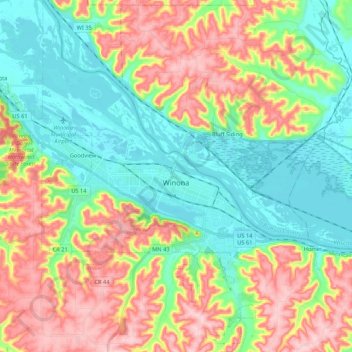
Name: Winona topographic map, elevation, terrain.

Location: Winona, Winona County, Minnesota, 55987, United States (43.97672 -91.72046 44.12923 -91.59129)

Average elevation: 272 m

Minimum elevation: 193 m

Maximum elevation: 394 m

Other topographic maps

Click on a map to view its topography, its elevation and its terrain.

Pickwick

United States > Minnesota > Winona County

Average elevation: 278 m

Gear up for your next adventure:

📢Survival Whistles - Essential safety gear for signaling for help in mountain fog
🔭Compact Hiking Binoculars - Lightweight optics for scouting terrain and spotting wildlife
👟Men's Trail Running Shoes - Lightweight grip for fast movement over topographic contours
🧣Neck Gaiters - Protects against wind and sun on exposed ridges and peaks
🥾Men's Waterproof Hiking Boots - Durable footwear with deep lugs for muddy and rocky UK terrains

As an Amazon Associate, this site earns from qualifying purchases at no extra cost to you.