Geolocate

Parchal topographic map

Click on the map to display elevation.

About this map

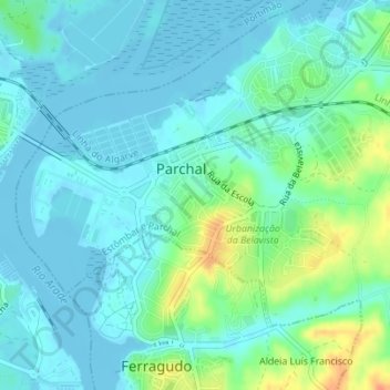
Name: Parchal topographic map, elevation, terrain.

Location: Parchal, Estômbar e Parchal, Lagoa, Faro, Portugal (37.12631 -8.53241 37.14503 -8.49782)

Average elevation: 10 m

Minimum elevation: -3 m

Maximum elevation: 40 m

Gear up for your next adventure:

👟Waterproof Leg Gaiters - Keep mud and water out of your boots in boggy terrain
🧭Emergency Beacons - Safety beacons for remote outdoor locations
🍱Food Containers - Reusable containers for outdoor meals
🪓Outdoor Multitools - Versatile tools for hiking and camping
🧊Personal Water Filters - Drink safely from mountain streams marked on your map

As an Amazon Associate, this site earns from qualifying purchases at no extra cost to you.