
El Indio topographic map
Interactive map
Click on the map to display elevation.
About this map
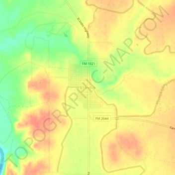
Name: El Indio topographic map, elevation, terrain.
Location: El Indio, Maverick County, Texas, 78860, United States (28.49415 -100.33162 28.53415 -100.29162)
Average elevation: 222 m
Minimum elevation: 190 m
Maximum elevation: 240 m
Other topographic maps
Click on a map to view its topography, its elevation and its terrain.
Eagle Pass
United States > Texas > Maverick County > Eagle Pass > Eagle Pass
Eagle Pass, Maverick County, Texas, 78852, United States
Average elevation: 252 m
Maverick County
United States > Texas > Maverick County
Maverick County, Texas, United States
Average elevation: 247 m
Eagle Pass
United States > Texas > Maverick County
Eagle Pass, Maverick County, Texas, 78852, United States
Average elevation: 231 m