
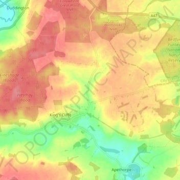
King's Cliffe topographic map
Interactive map
Click on the map to display elevation.
About this map
Name: King's Cliffe topographic map, elevation, terrain.
Average elevation: 69 m
Minimum elevation: 27 m
Maximum elevation: 96 m
Other topographic maps
Click on a map to view its topography, its elevation and its terrain.
Bluebell Lakes
United Kingdom > England > East Northamptonshire
Bluebell Lakes, Woodnewton Road, Woodnewton, East Northamptonshire, Northamptonshire, East Midlands, England, PE8 5HX, United Kingdom
Average elevation: 23 m
Bulwick
United Kingdom > England > East Northamptonshire > Deene
Bulwick, Deene, East Northamptonshire, Northamptonshire, East Midlands, England, United Kingdom
Average elevation: 88 m
Willow Brook
United Kingdom > England > East Northamptonshire
Willow Brook, East Northamptonshire, Northamptonshire, East Midlands, England, PE8 6XQ, United Kingdom
Average elevation: 63 m